




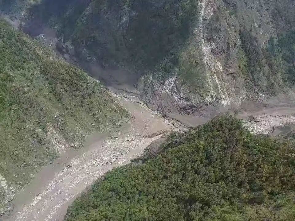
SATV, Kathmandu, August 29 | At approximately 9 a.m. on August 26, a massive and sudden debris flow swept across the Gyirong-Rasuwagadhi port along the China-Nepal border. As of press time, on the Chinese side, 7 fatalities and 554 missing persons have been confirmed, including 260 foreign nationals. On the Nepali side, data released by Nepal’s National Disaster Risk Reduction and Management Authority (NDRRMA) show that the death toll in northern Nepal has risen to 626, with as many as 1,924 people still unaccounted for. The transboundary mega-disaster has drawn intense focus from China, Nepal, and the wider international community — particularly regarding the origin of the event, the adequacy of early warnings, and its scientific causes. Drawing on multiple sources, South Asia Network TV has compiled the following overview of these three core issues.
I. Nepal’s Response to China’s Attribution: “Disaster Originated on the Nepali Side”
On August 27, the day after the disaster, China’s Ministry of Natural Resources released a preliminary assessment via official channels: the Gyirong debris flow in Tibet was triggered by a high-altitude ice avalanche within Nepali territory, which generated an ice-rock avalanche debris flow that subsequently evolved into a debris flow chain disaster. The source was pinpointed to the upper reaches of the Cuojian River, a tributary of the Guoba Xiaqu, itself a tributary of the Donglin Zangbu River, upstream of the Gyirong port. The ice avalanche originated at an elevation of approximately 5,140 meters, covering a total area of 620,000 square meters.
This attribution quickly drew attention: does Nepal accept this conclusion?
Nepali experts have publicly acknowledged that the source lies on the Nepali side. On August 28, Professor Binod Dawadi of Tribhuvan University in Nepal, in an interview with CCTV, marked the disaster’s starting point on a map and explicitly stated: “The initial source of this debris flow disaster is on the Nepali side.” Pointing to a location above the Liru Glacier on the map, he said: “This point on the Nepali side is above the Liru Glacier, and this is where the disaster originated.”
Dawadi’s remarks represent the first time a Nepali academic has openly and unequivocally confirmed that the disaster’s origin lies within Nepal.
The Nepali government’s initial statement showed some deviation. According to China News week, Nepal’s Foreign Minister had earlier suggested that the disaster was caused by a large landslide triggered by a magnitude 4.4 earthquake. However, subsequent investigations by the U.S. Geological Survey indicated that the so-called “earthquake” tremors were actually generated by the glacier collapse and the debris flow itself. China’s Earthquake Administration also clarified on August 27 that at the time of the debris flow, vibrations resembling a magnitude 5.1 earthquake were detected about 20 kilometers from the Gyirong port; waveform analysis confirmed these were seismic signals generated by the surface debris flow, not a tectonic earthquake.
China’s diplomatic channels have been cautious yet clear. At a regular press conference on August 27, Chinese Foreign Ministry spokesperson Lin Jian stated: “We have noted that experts and official agencies from both China and Nepal have made some assessments and analyses of the causes of this disaster, concluding that it was triggered by a high-altitude glacier collapse within Nepali territory.” He added that further verification is ongoing and that China has notified the relevant embassies in Beijing.
Notably, on the afternoon of the disaster, the Belt and Road Disaster Risk Reduction Service Team of Central South University received requests for satellite remote sensing and disaster analysis support from both Nepal’s NDRRMA and the National Center for Disaster Management (NCDM). By 9 a.m. on August 27, the team submitted its preliminary findings to both Nepali agencies, likewise locating the disaster’s initiation zone in a high-altitude, snow-covered area on the Nepali side, approximately 13 kilometers east of the Gyirong port.
As of press time, the Nepali government has not issued an official statement on the source attribution. Nevertheless, the public confirmation by a leading Nepali expert, Nepal’s request for and acceptance of assistance from the Chinese academic team, and communications through diplomatic channels all point to a consensus at the expert level: the disaster originated from a high-altitude ice avalanche within Nepal.
【Embassy Statement】
Chinese Embassy in Nepal Officially Refutes Rumors: Rasuwa Disaster Not Caused by Chinese Dam Breach; No Early Warning Failure
In response to recent claims in Nepali public discourse, the Chinese Embassy in Nepal has issued an official clarification, denying that the Rasuwa flood disaster resulted from a dam collapse on the Chinese side, while also refuting allegations of a failure in early warning by China.
The embassy stated that the massive Rasuwa flash flood was triggered by an ice-rock avalanche on the Nepali side on the morning of August 26, which generated a large-scale debris flow, causing casualties and property losses on both sides of the Gyirong-Rasuwagadhi border crossing.
The embassy explicitly rejected two types of rumors: that China failed to provide timely warnings, and that the disaster was caused by the breaching of a Chinese dam or barrier lake. It emphasized that the disaster originated from a high-altitude glacial area in Nepal, not from the collapse of any Chinese water infrastructure.
The embassy stressed that in the face of such a catastrophe, rescue and relief efforts are the top priority, and groundless accusations serve no purpose. It called on all parties to join hands in rescue operations, save lives through cooperation, and jointly address the challenges posed by transboundary geological disasters.
II. On the Claim That “China Failed to Issue Timely Warnings”
In the aftermath of such a mega-disaster, the question “why was there no early warning” has become one of the most painful and pressing inquiries. Online rumors have suggested that “China did not warn in time.” South Asia Network TV has conducted extensive verification and presents the factual timeline below.
First, it must be made clear: the gap in early warning systems lies on the Nepali side, not the Chinese. Nepali expert Binod Dawadi stated bluntly in an interview: “Because there is no early warning system yet, information could not be obtained in time, resulting in severe damage to the border area.” This admission by a Nepali expert clearly identifies the root cause — the lack of an early warning system in Nepal’s high-altitude glacier zones.
Second, even if a warning had been issued, the response window would have been extremely narrow. Professor Dawadi calculated that the straight-line distance from the ice avalanche point to the border port is about 13 kilometers, yet the flood reached the border in just 10 minutes. China’s Ministry of Natural Resources provided even more precise figures: the average flow velocity of the ice avalanche debris reached 50 meters per second, and from glacier collapse to debris flow impact at Gyirong port took only 7 minutes, covering a 20-kilometer path with a vertical drop of nearly 3,300 meters.
“What does 50 meters per second mean? It’s like a car speeding on a highway. In 7 minutes, from the ice avalanche point at over 5,000 meters elevation down to the port at 1,830 meters, with no buffer along the way,” said a geological engineer involved in the rescue effort. “At that speed, even if upstream monitoring detected the avalanche, every step — information transmission, decision-making, notification, evacuation — would take time. There simply would not have been enough time.”
Third, precursor signals for ice avalanches are inherently difficult to detect. Professor Shen Yanjun from the School of Geological Engineering and Geomatics at Chang’an University, in an interview with China Newsweek, explained that ice-rock avalanches are a type of “brittle failure” in physical mechanics: “It’s not like something slowly bending and toppling over. Before reaching its critical state, it remains completely still. Unless specialized ground-based equipment is continuously tracking specific rock masses, it is very difficult to monitor the moment when it crosses the threshold.”
Moreover, the source area lies at an altitude above 5,000 meters, is inaccessible, and does not allow for detailed on-site geological structural surveys. Shen noted that this disaster closely resembles the 2021 ice-rock avalanche in the Niti Valley of Chamoli district, Uttarakhand, India — and “precursor signal identification for this type of disaster is generally difficult.”
Fourth, the claim that “China failed to warn” lacks factual basis. South Asia Network TV has reviewed all publicly available reports as of press time and has found no statement from the Nepali government or any official agency accusing China of failing to provide timely warnings. On the contrary, Nepali experts have openly acknowledged their own country’s lack of early warning systems; and both Nepal’s NDRRMA and NCDM requested satellite remote sensing support from Chinese academic teams immediately after the disaster, rather than raising any warning accountability issues.
In his directive following the disaster, Chinese leadership specifically emphasized the need to “strengthen monitoring and early warning.” On August 28, a meeting of the Political Bureau of the CPC Central Committee, which studied and deployed rescue and relief work, also listed monitoring and early warning as a key priority.
Experts recommend that cross-border joint early warning is imperative. Professor Wu Lixin of Central South University, an academician of the International Eurasian Academy of Sciences, told the media that one feasible approach is to install more intelligent sensing devices along low-altitude transport routes, settlements, and key infrastructure, enabling rapid alerts when anomalies are detected. He also called on countries worldwide to break down barriers to satellite observation data and increase openness and rapid sharing. “Natural disasters know no borders and are beyond human control. In the face of mega-catastrophes, we may all be victims, so we must join hands and respond together.”
III. Expert Analysis of Disaster Causes
This catastrophe, described by many experts as “one of the most severe glacial disasters in the Himalayas in recent years,” raises the question: how exactly did it happen? South Asia Network TV has synthesized the assessments of authoritative Chinese and Nepali experts to outline the causal chain.
(1) Direct Trigger: High-Altitude Glacier Collapse
Experts from both China and Nepal agree that the direct trigger of the disaster was a high-altitude glacier collapse within Nepali territory.
Guo Zhaocheng, Director of the Geological Hazard Survey and Monitoring Center at China’s Aero Geophysical Survey and Remote Sensing Center for Natural Resources, explained that high-resolution remote sensing images identified a high-altitude ice avalanche in the upper reaches of the Cuojian River, a tributary of the Guoba Xiaqu, itself a tributary of the Donglin Zangbu River, within Nepal upstream of the Gyirong port. “The high-altitude ice avalanche collapsed from the mountain slope, scouring glacial debris in the gully during high-speed movement, forming a high-speed debris flow that traveled along the gully, evolved into a debris flow, and struck the port facilities and areas beyond the border.”
Nepali expert Binod Dawadi offered a more detailed description: “First, rising temperatures caused glacier melting, putting it in a state of near-avalanche. The ice avalanche then triggered a so-called ‘chain reaction,’ entraining rock debris mixed with large amounts of ice particles, accompanied by minor landslides and permafrost disturbances. These factors combined to produce a mixture of mud, ice, and water.”
(2) Amplification Mechanism: Stepwise Cascade Amplification
The most striking feature of this disaster is the typical “disaster cascade effect” — after the ice avalanche, the energy was transmitted downstream along the valley and river channels, amplifying step by step, with destructive power increasing further downstream.
Academician Yao Tandong, leader of the Second Tibetan Plateau Scientific Expedition and a member of the Chinese Academy of Sciences, pointed out: “From a scientific mechanism perspective, this disaster exhibits a typical cascade effect: after the ice avalanche, the energy propagated downstream along the valley, amplifying stepwise. The farther downstream, the stronger the destructive power and the more prominent the secondary risks.”
The specific amplification path was: the avalanche mass descended at high speed from about 5,140 meters elevation → scoured moraine material in the gully, forming a high-speed debris flow → merged into the Sino-Nepal boundary river Guoba Xiaqu, flowing westward into the Donglin Zangbu → evolved into a highly impactful debris flow → formed a temporary blockage in the Lunde River, which upon breaching produced even greater impact → ultimately struck the Gyirong port, then continued in two directions: one branch surged nearly 3 kilometers upstream along the Gyirong Zangbu, while the other flowed downstream into Nepali territory, affecting a distance of tens of kilometers.
Experts are divided on whether there was a “river-blocking dam-break” phase. Wu Lixin’s team believes there may have been a process of ice-rock “blockage forming a dam — sudden breaching.” However, Professor Shen Yanjun of Chang’an University considers this less likely, as seismic network data showed only one major vibration signal; if there had been river blockage and secondary breaching, a second vibration signal would have appeared. “Currently, there is no direct evidence that this disaster involved river blockage and dam breaching.”
(3) Deep-Seated Root Cause: Global Climate Warming
If the high-altitude ice avalanche was the direct cause, then global climate warming is the deeper root cause.
Academician Yao Tandong explicitly stated: “The increasing frequency, expanding impact, and intensifying damage of such glacier disasters are a new and prominent feature of cryospheric disasters on the Tibetan Plateau and its surrounding areas under the context of global climate warming.”
Professor Shen Yanjun explained from a mechanical perspective how climate warming leads to ice avalanches: the Gyirong port area lies in a global maritime glacier zone, making it more susceptible to climate warming. “Ice acts like a binder or tape, adhering rocks to the slope. Once the glacier melts, this bonding effect is lost, and rocks are prone to detachment.”
He further explained that if heavy rainfall or meltwater seeps into the cracks on both sides and the trailing edge of the ice-rock mass, it creates water pressure that weakens overall stability; when the crack water freezes at low temperatures, it generates expansion forces that further pry open the cracks. Over repeated cycles, the ice-rock mass eventually reaches a critical state of instability. “With even the slightest external disturbance, it is prone to fracture, collapse, and sliding.”
Data support this judgment: before the ice avalanche, surface temperatures in the area reached their highest levels in nearly two years. Moreover, there was no significant precipitation in the affected area before the disaster — meaning this was not a traditional rainfall-induced debris flow, but a glacier disaster driven by climate warming.
(4) Topographic Conditions: Extreme Elevation Difference Produces Extreme Destructive Force
Xu Qiang, President of Chengdu University of Technology and Chief Scientist of the State Key Laboratory of Geohazard Prevention and Geoenvironment Protection, noted that the ice avalanche source area is at about 5,000 meters elevation, while the Gyirong port is at only 1,830 meters — a vertical drop of over 3,000 meters. “This enormous elevation difference not only generates tremendous potential energy but also easily breaks up ice and rock, enhancing fluidity.”
Radar satellite imagery from Wu Lixin’s team showed that the flash flood-debris flow swept downstream, scouring the riverbed to an average width of over 300 meters, and up to 600 meters in places — whereas normally, the water surface width of the Donglin Zangbu and Bhotekoshi rivers is less than 100 meters. “Buildings and facilities along the banks suffered devastating destruction.”
Video footage showed that the debris flow wave that struck the Gyirong port reached over 20 meters high, instantly destroying multi-story buildings. The debris flow deposited material about 1.5 meters thick at the port area, with deeper silt in the core disaster zone, making it difficult for personnel and heavy machinery to enter.
(5) Distinction from the “7·8” Disaster of 2025
Notably, this is the second major debris flow disaster to hit the Gyirong port area in just over a year. On July 8, 2025, a flash flood-debris flow in the Gyirong port area caused 17 Chinese nationals to go missing and destroyed the Sino-Nepal Friendship Bridge. However, experts emphasize that the causal mechanisms differ: the “7·8” disaster last year was a glacial lake outburst flood (GLOF), whereas this one was a chain-reaction debris flow triggered by a high-altitude ice avalanche, with greater impact force, longer travel distance, and higher warning difficulty.
Preliminary source tracing by the Cryosphere Emergency Disaster Mitigation Team of the Institute of Mountain Hazards and Environment, Chinese Academy of Sciences, indicated that the source of the flash flood-debris flow points to a sub-basin of the Qiaochen Valley in the Donglin Zangbu basin within Nepal, covering an area of 38.40 square kilometers, containing four glaciers with a total area of about 6 square kilometers. The stability of glaciers in this region is facing ongoing challenges under climate warming.
Conclusion
The catastrophic debris flow at the China-Nepal Gyirong port is a typical transboundary chain-reaction glacier disaster. Its origin lies on the Nepali side — a conclusion now shared by experts from both countries. The failure of early warning stems from gaps in monitoring capacity in high-altitude glacier zones, not from negligence by any single party. Its cause is a microcosm of cryosphere destabilization driven by global climate warming.
As Professor Wu Lixin aptly put it: “Natural disasters know no borders.” In the face of increasingly frequent glacier disasters in the Himalayas, China, Nepal, and the broader international community must strengthen cross-border joint monitoring and early warning, share satellite data, and build an integrated space-air-ground early warning system. Only then can we secure more precious time for downstream populations to evacuate before future mega-disasters strike. (End)
Data Sources:
Chinese casualty data: Tibet Autonomous Region Emergency Management Department, as of August 29, 2026
Nepali casualty data: Nepal National Disaster Risk Reduction and Management Authority (NDRRMA), as of 19:00, August 28, 2026
Disaster cause assessments: China Ministry of Natural Resources; Nepali expert Binod Dawadi; CAS Academician Yao Tandong; Central South University (Wu Lixin team); Chang’an University (Shen Yanjun); Chengdu University of Technology (Xu Qiang); Institute of Mountain Hazards and Environment, CAS
Reporting references: Xinhua News Agency, Xinhuanet, China Newsweek, CCTV News, China Tibet Online, Guangming Online, Chinese Foreign Ministry regular press briefings.